top of page
  • Writer: Batasari Travel Tales
    Batasari Travel Tales
  • Dec 14, 2025
  • 6 min read


Check list:

Trek Grade

Difficult (single day category)

Hydration

​2 bottles must. Hydration pack preferred.

Backpack

​20 to 25 L

Clothing

whichever is comfort. Carry a fleece as it will be windy on 6th & 7th hill at times.

Trek shoe

Most of the trekkers does with bare foot but i use shoes.

Trek Duration

Into fitness - 9 to 11 hours, beginners - 12 to 14 hours.

Time of trek

Night preferred to avoid Harsh sun and also water sources are less.

Season

Opens before Maha shivaratri and closes by end of April.


Caution - Before descending, please carefully copy the checklist. Over the past few years, there have been several casualties on this hill due to cardiac arrests. This is primarily because people underestimate this trek and come unprepared, particularly in terms of hydration. Make sure you are well-hydrated and ascend slowly through elevated areas.


How to reach:


Flight/Bus/Train - Arrive in Coimbatore, a city with excellent connectivity to major Indian cities via air, rail, and road. From Coimbatore, you can hire a taxi to Poondi, located approximately 35 kilometers away.

Public transport from Coimbatore - From the Gandhipuram bus stand in Coimbatore, there are direct buses to Poondi (Velliangiri Hills). Take bus number 14D.


Trek Day:


Three of us took a train from Chennai, boarding the Kovai Express at around 6:05 am from Chennai Central. We arrived in Coimbatore around 2 pm.

Directly across from the station is a vegetarian restaurant called 'Akshay,' where we had lunch. They offer both South and North Indian meals, along with a variety of other dishes. There isn't a suitable hotel near the base camp or starting point of the trek, so it's advisable to eat in Coimbatore or bring your own lunch boxes.


After lunch, we drove to Poondi. The GPS provides accurate directions if needed. Public transport information is mentioned above. On the way, we passed several grape farms and the route runs right next to Sadhguru’s Isha Center.

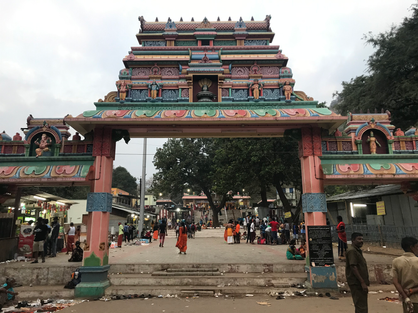
We arrived at the temple, the starting point of the trek, after a 40-minute drive, around 4 pm. There is a large parking area available with no parking fees.


Some members of our group brought Chapati, which was shared with everyone. It's essential to bring your own food since the shops along the trail only offer beverages, soups, and Sukka coffee. The small hotels near the parking area also don't provide good food. Keep in mind that food should be packed in paper, as plastic is prohibited.


Upon entering the temple compound, you'll find a shed to the right that sells bamboo walking sticks, each priced at Rs. 30. To save this money, you have two options: 1. Bring your own trekking pole, or 2. Continue to the start of the steps, where you'll find sticks left by returning trekkers on the right. You can pick one up there.


You can fill your water bottles at the temple compound. If you arrive during lunchtime, you might find the temple offering free Annadanam. They also serve breakfast in the mornings.


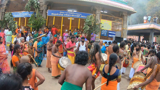
Since it was a full moon day, we had the opportunity to witness the Rath Yatra and the traditional dance performed by the Siddas. At 5 pm, our group proceeded to the bag check located at the entrance of the steps. The process took only about five minutes because we had already stored our excess luggage in the car and didn't carry any plastics.


I performed a final inspection of the bag, removed the head torch, and confirmed that the hydration pack was already filled. At 5:30 pm, we commenced the trek.


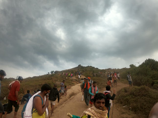
Here's an overview of this trek: You'll need to climb seven hills, covering a distance of 5.4 kilometers one way (as measured by my Garmin watch), totaling 10.8 kilometers for the entire trek. The first and last hills are the toughest to ascend. Completing the trek typically takes around 10 to 12 hours. These are crucial details to know before embarking on this trek.


Despite this, the Velliangiri Hills are regarded as some of the most challenging mountains to climb in South India.


With great enthusiasm and energy, it took approximately 55 minutes to conquer the first hill, which spans a distance of 0.8 km. The climb is steep and challenging. Be sure to take sufficient breaks based on your fitness level. Keep in mind that the first hill will test both your physical and mental endurance, tempting you to quit. At the top of the first hill, you'll find the Lord Vinayaka temple. Seek blessings and make sure to hydrate. There are also small shops available here.


We waited for about 15 minutes to gather there before beginning our journey to the Second Hill.


The second hill isn't very challenging. The trail consists of a combination of steps and walkable paths. After approximately 15 to 20 minutes of trekking, we arrived at the first water source.

You can refill your bottles here if needed. It took us 30 minutes to finish the second hill. At the end of this hill, there is a cave temple called Pambatti Siddhar Cave. We reached there at around 7:30 pm, taking several breaks and waiting for other team members to catch up.


The trail of the third hill is similar to that of the second hill. However, there are some difficult patches to walk through. After approximately 15 minutes of trekking on the third hill, there is a second stream. We decided to eat to regain some energy. We finished our meal (the chapati we brought), refilled our water bottles, and resumed our trek. We continued climbing the fourth hill without taking any breaks. Since it was a full moon night, we could clearly see the surrounding areas, including the Isha Foundation.


After a brief pause, we began our trek to the fifth hill around 9 p.m. It had been three and a half hours since we started the journey. The fifth hill, like the fourth and third, is also among the easier ones. On your right, you will find the Jeeva Samadhi of Ottan Siddhar, who is thought to have constructed the steps of the Velliangiri Hills.


The sixth hill begins with a flat area, and as we descend, we encounter sections where the path is severely damaged, requiring us to be careful. This is particularly important when there are people coming from the opposite direction, as it can cause traffic jams.

After descending for some time, we arrived at a sacred pond at the base of the sixth hill. It is believed that bathing here cleanses one of all sins. The water is ice-cold, so be mindful of its cleanliness. I bathed here last year but chose not to this time due to the crowd.


After spending a few minutes at the pond, we headed towards the Seventh Hill. We enjoyed some herbal soup and took a short break at a small stall. At 10:30 pm, we began our ascent up the steep section of the Seventh Hill. This hill tests both your physical and mental endurance before reaching the cave temple at the summit. The trail is rough and very dusty.

With several breaks, it took us an hour to reach the summit.

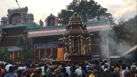
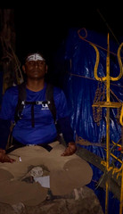
The crowd at the cave temple was smaller, allowing us to have an incredible darshan. This time, they permitted us to take pictures as well. At my request, the priest explained the names of the five lingas. In total, there are five lingas: three are located inside the rock cave, the fourth is the rock itself, which forms a cave, and the fifth is the seventh hill.


The five aspects of Lord Shiva—Brahma, Vishnu, Rudra, Maheshwara, and Sadasiva—are represented as Panchagiri and Panchalingas, corresponding to the panchabhutas, in Velliangiri.


Around 12:15 am, we finished the darshan and sat there for a while. We then descended to the Sixth Hill and rested for a bit.


With several breaks, we completed the trek at approximately 5:30 am, totaling 12 hours.

The time it takes can vary based on your fitness level. The first time I climbed, it took me 20 hours. Ensure you get enough rest the day before so your body can handle the trek.


Watch my vlog on https://www.youtube.com/c/batasaritraveltales for visuals.


Drop a comment if you need any details on this trek. Thanks for staying tuned!


Batasari travel Tales - Enabling Travellers to plan their own Treks & Trips.


Trekking in Seshachalam is a dream for me and many trekking enthusiasts, as there are restrictions on most of the trekking peaks. Aside from a few easily accessible waterfalls, most in Seshachalam are not open to the public.

A post on Instagram caught my attention: the Thumburu Theertham trek! Deva Theertham is on the way to Thumburu Theertham, though with a slight detour. You'll learn how the plans evolved as we progress through this article.


Until the day before the trek, the organizers hadn't confirmed our spots because they needed clearance from the forest department. However, by Friday evening, I received a call saying we could join. My friend and I prepared for the overnight trek in Seshachalam.

This is my first trek with a Telugu-speaking group in Andhra Pradesh, and I'm quite thrilled. We've scheduled our departure from Chennai at 5 am because we need to arrive in Tirupati by approximately 9 am. The journey typically lasts about 3 hours, or around 4 hours if we opt for public transport.

Though it's a short trek but includes an overnight stay, we must be mindful of what we pack.


  • 25 to 30L backpack

  • Full sleeve T shirt & Trek / track pants – Must as trail has lot of bushes and small thorns, insect bites

  • Water bottle – 1L must (2L optional)

  • Snacks – Required

  • Space clothes – for water dip/swim

  • Sleeping bag / Bed sheets – Must as we will be sleeping outdoor (if you don’t carry your own tent)

  • Tent – Required to carry (organizers cover sleeping area with turpentine/banner covers.


The meeting point was across from the Tirupati bus stand. Our group of 35 had bus transportation arranged from there to the trek's starting point, "Kukkala Doddi." After a half-hour drive, we arrived at the starting location. There wasn't much in terms of briefing; we all set off on the trail without delay. Lunch packs were distributed to everyone, and I took responsibility for them. We also had to carry various items related to cooking and the overnight camp, which were distributed among us.


The trail is flat and accessible to both four-wheelers and two-wheelers. The organizers had a few bikes with them, so they transported the luggage on bikes to ease the burden for some trekkers. Some trekkers who came on their own also rode their bikes down the trail.

From the very start, elephant dung and footprints are visible along the trail. It seems that an elephant passed through the trail just a few hours ago.

After trekking around 2 kilometers, we encountered Annamayya Margam, which connects to Tirumala. This route is opened to the public on one of the auspicious days.

After trekking approximately 3.8 kilometers, there is a dry river crossing the trail, where bikes are parked. Beyond this point, the forest becomes thick and dense, and we proceed along the riverbed, which is lined with bushes.


At approximately 1:30 pm, we paused for a lunch break beneath a tree in the riverbed. Up to this point, we had trekked roughly 4.2 kilometers. Initially, the lunch was planned for a different location, but due to a lack of coordination, everyone was left to their own devices. By around 2 pm, we resumed our hike. Our goal is to cover about 6 to 7 kilometers in 4 hours, which means we need to hurry before the sun sets.

The trail is clearly marked with paint on the rocks. It runs alongside the riverbank but switches from one side to the other. Walking in the river is not advisable due to the presence of large boulders, which can significantly slow down progress.


Whenever we encounter a crossing or a passage through the river, we find a path along the bank and proceed forward. The trail becomes denser, turning into more of a bamboo forest with red sandalwood. As we pass through some of the thicker areas, mosquito bites are quite common. If possible, apply mosquito repellent to your hands and neck. Fallen bamboo trees have blocked the trail in several places due to disturbances caused by elephants.

After about a 30-minute trek, we reached a cave known as “sanyasi gruha.” It is situated right next to the stream. The water is very tasty and crystal clear. Until this point, my water intake was minimal, but upon seeing such clear, flowing water, I drank about a bottle and refilled it. From here, the stream contains water, and we are very cautious while crossing. In fact, all of us ended up in the water during some of the crossings.


The required pace was 1.5 to 2 km/h, and we are on track. The trail is very narrow, allowing only one person to walk at a time. There are long branches lying on the path, and some of us have tripped because our shoes got caught. We need to be very careful as there are small thorns that are scratching us. Ahead of us, about five trekkers have gone, and the guide, who is also the cook, was among them. By 5:50 pm, we reached the "Vengamamba Gruha." It’s a large rock cave with a small shrine dedicated to a Guru called “Sri Raj Guru,” although Vengamamba offered prayers from here.


As you may remember from our previous discussion, the journey began towards "Thumburu Theertham." The theertham is approximately 2 kilometers from this point. We will stay here overnight and resume our trek to Thumburu Theertham tomorrow morning.


Those with their own tents have set them up, and the organizers mentioned they would provide a plastic sheet or banners for us to sleep on. There won't be any overhead cover or roof. Elephants have even wandered through our campsite. I decided to sleep inside the cave, which offers overhead cover and is elevated, making it safer. There are two campfires, and people have formed groups, participating in various fun activities.

Dinner was prepared by 10 pm, consisting of rice, sambar, rasam, and bajji, served with curd. Many of us were exhausted since it was late.

During this time, four forest guards were camped nearby, and they were having a serious conversation with our organizers. They asked us to gather in one spot for a photo. I noticed discussions were underway, but I kept my distance. Before bedtime, someone mentioned that we might be prevented from visiting Thumburu Theertham.


Woke up at around 6:30 am after sleeping for about 7 hours without needing to get up during the night. Typically, sleep quality is excellent in the forest or outdoors. Although it was a cold night, my sleeping bag kept me comfortable.

Everyone at the campsite woke up to the news that we weren't allowed to go to Thumburu Theertham. Some of us approached the forest rangers and explained that we had traveled from all over India, but we had no success.

Tea was prepared over the campfire, and refreshments were enjoyed afterward. Card rice was made using the leftover rice from last night, and we tasted a bit before departing the campsite.The morning hike along the water stream was wonderfully pleasant and scenic.


After hiking approximately 6 kilometers, we've arrived at the point where we need to take a diversion. The chef has begun preparing lunch there so it will be ready when we return from Theertham. We walked through dense bushes for about 300 to 400 meters and reached Deva Theertham.

Firstly, there is no crowd in the falls since it is closed to the public. The water flow is good, and there is a sufficient pond below for swimming or bathing. The depth increases as you approach the fall, but it is about 4 to 5 feet deep in the middle, allowing anyone to enter and enjoy. We spent around 30 minutes there before climbing to the top of the fall. The path is quite dangerous and narrow, requiring navigation through rock cuts and tree branches, so we had to be accompanied by trek guides.

It appears that this Theertham contains approximately 12 Gundams in total if we keep climbing. With assistance from the guides, some of us began the ascent, and after around 10 minutes, we arrived at the top of the waterfall, where the views are breathtaking. There is a small Gundam right at the top of the waterfall, and the path continues up towards another main fall known as "Rushi theertham." Wearing shoes is definitely not recommended, so I had to go barefoot.


After a hike of about 15 minutes, we arrived at the upper falls, which is much larger and deeper than Deva Theertham. Only a few people ventured down due to its depth. I meditated there, while some experienced swimmers dived in. We spent about 30 minutes before returning to Deva Theertham and then headed back to our lunch spot. We enjoyed pulihora by the water stream and rested for a while, filling our bottles before departing. We had another 5-kilometer hike before reaching the road head. I had been asking our trek guide to show me a Red Sandalwood tree, and he mentioned that we had passed many along the way. Finally, we spotted a few trees right next to our path. We reached the road head around 3:30 pm.

We hadn't arranged for transportation, so we took a tractor ride to Tirupati until Renigunta Junction, and from there, we took a bus. We arrived in Tirupati by 5 PM and immediately started our journey to Chennai.


If you'd like to see a visual representation of my article, please watch my vlog on YouTube and leave a comment if you have any questions.  


Updated: Feb 20, 2025

Kotappa Konda is one of the famous Lord shiva’s shrine in Andhra Pradesh. It is combination of three hills / Trikuta hills. Kotappa Konda hill appears with 3 peaks in any direction so it's also called as Trikutadri, Trikuta Parvatham. The three hills are Brahma hill, Vishnu hill and Rudra hill.

  1. Brahma Shikharam: The main temple Trikoteswara Swamy Temple is located here.

  2. Rudra Shikharam: Old Kotayya temple is located here. This is the first place where Trikoteswara Swamy existed. Hence it is called Paatha (old) Kotayya Temple.

  3. Vishnu Shikharam: Lord Paapanaseswara Temple is here. It is believed that Lord Vishnu did penance for Lord Shiva. There is also a holy pond "Paapanasa Teertha" here.


Directions: This location is approximately 12 kilometers from the Palnadu district headquarters and 50 kilometers from Guntur. It can be easily reached via NH 16 through Chilakaluripet. The nearest railway station is Narasaraopet. Frequent daily buses are available from both Narasaraopet and Chilakaluripet.

The temple can be reached via the Ghat road or by taking the steps. Most devotees / visitors opt for the Ghat road because it is more convenient. Taking the steps usually takes about 30 to 45 minutes to reach the temple.


My hometown is located approximately 40 kilometers from this temple, and I have been visiting it for several years. Last year, I even created a vlog about the temple, providing all the necessary details for anyone interested in visiting.

Three hills and a temple are clearly visible from the Guntur and Kurnool state highway. A few years ago, while observing the hills, I spotted a small temple atop the tallest hill, known as Rudra Giri. During a conversation with friends, I learned that this is the original KotappaKonda temple, where God first appeared, and it is called "Patha Kotaiah / Old Kotaiah Konda." Since then, I've been eager to climb to the top.


Finally, the day has come. This time, I wanted to do something a bit different. The destination is about an hour's drive from my hometown. After lunch, I started around 3 pm and arrived at the starting point of the steps by 3:50 pm. There were very few vehicles in the parking area, so there were no issues, which is typical unless it's a special day. There is a temple administrative office and small stalls. Some devotees break coconuts before climbing the steps and perform a ritual at each step.


Things to carry:

  • Water - 1 L

  • Shoes - Mandatory, if you would like to climb Old Kotayya Konda. If you are going till new temple, Shoes are not required.

  • Full sleeves T shirt, as this place is too hot even in winter noon.

  • Snacks or nuts if you need something to munch.

Steps starting point

I'm ready for the hike, equipped with a water bottle, trail shoes, and a Buff. I'm carrying a small hiking backpack since I have my Drone and Insta 360 with me.

Currently, my plan is to climb only up to Patha Kotayya Konda and return. I'll let you know later if it turns into a circuit trek. I took a couple of pictures at the starting point of the steps and began the hike. There's a small Gopuram at the beginning of the steps. I didn't make any effort to find out how many steps there are to the temple, which will be the final milestone of this journey.

Steps view
Steps view

It was a particularly hot day, despite it being winter. This area tends to be even hotter during the summer. Even at 4 PM, the heat persisted. It took me about 15 minutes to reach the "Ananda Valli ashram," the first temple at the end of the steps before reaching the giant Shiva lingam in front of the temple. I offered prayers from outside and arrived at the footprints of the Giant Lingam. From its base, I climbed the steps to stand before it. This is probably one of the largest Lingams I have seen so far. I also offered prayers to "Trikoteeswara Swamy" from outside and continued my hike up the steps. The path leads to the right side of the temple, where there is a Mandapam for Nagendra Swamy. At this small Mandapam, the steps end, and the trail begins towards "Patha Kotayya" Konda. A signboard there indicates the way.


Temple with intricate tower in bright sunlight, set against hills. Few people walking towards the entrance. Blue sky, serene atmosphere.
Current temple on Brahma girl hill

We will embark on a rocky and uneven trail leading to our destination. It seems the devasthanam board created this path a few months ago. After walking approximately 300 meters, the path emerges from the shade, and the sun begins to blaze. The route becomes steep and somewhat challenging to climb. I had to take several breaks to avoid becoming too exhausted.


Halfway up, I encountered water storage tanks that were operational. The devasthanam board made efforts to ensure devotees do not suffer. After about a 30-minute hike, I reached the top. The distance from the temple to the top is around 800 meters.

While climbing, I happened to meet a pujari who informed me to meet someone at the temple to explain the history of the deity and show me around the temple.


The Patha Kotayya temple is very serene, and the idol of Lord Shiva closely resembles Lord Mallikarjuna of Srisailam. I had the opportunity to take Darshan, and Mr. Venu, one of the temple's priests, permitted me to enter the Garbhalayam and touch the deity. They also explained the stalapuranam to me. They were very hospitable and encouraged me to share the greatness of Lord Shiva with the world.


Old Kotayya swamy
Old Kotayya swamy
Old Kotayya temple
Old Kotayya temple

Mr. Venu (priest) informed me that Vishnu Giri also features a temple and a pond. The trail from there connects to the road. He estimated the journey would take about an hour to an hour and a half. He also noted that there is no visible trail, but suggested following the dry grass along the way, as chemicals have been sprayed to remove the grass on the trail, and there are markings on the rocks in some areas. For a moment, I felt a thrill. I hadn't attempted such hikes solo, especially without knowing the path or timings. Without hesitation, I decided to embrace the challenge of this circuit trek.

From 5 to 5:30 pm, I spent time here and flew drone to capture some visuals. The drone lost signal, causing me significant anxiety, but thankfully, it returned safely. Around 5:40 pm, as the sun was setting behind the hills, I made my way towards Vishnu Giri.


I carefully followed the instructions given by the poojari to stay on the trail. Maintaining a steady pace was crucial because I had limited time before darkness fell. I balanced moving quickly with being cautious, as many areas had loose rocks and steep downhill sections. In some spots, we had to literally hold onto rocks to descend. The trail was surprisingly diverse, featuring woods, small rock caves, and steep sections. I slipped on one of the rocks, injuring my left knee and twisting my ankle. It took a moment to recover from the shock since it had been a while since I'd experienced something like this. I stood up and continued along the trail as the light gradually faded.


I ran on the trail wherever possible, but it was challenging to maintain speed due to my injury and the need to stay on the path. After about 40 minutes of hiking, I reached Vishnu Giri. There is a small temple and a pond beneath the rock. This pond, known as Paapanasa Teertha, is believed to cleanse one's sins if they take a dip or drink from it. A few water tanks are available for drinking water. I couldn't see the deity inside the dark temple, even with my phone light. I sprinkled some water on my head and began my descent immediately. As the light faded, I slipped on a rock, scratching my Insta 360 and sustaining a few minor injuries. Without time to pause, I got up and continued on the trail.

Trek Map
Trek Map

Starting from Vishnugiri, the path was lined with dense bushes and trees. Since I hadn't prepared for a night hike, I didn't have my torch or headlamp ready. There was still visible light at 6:20 pm. After another 10 minutes of a quick descent, I was at the base of the hill. I looked back to see the series of summits I had crossed, and with the fading light, the view was stunning. I arrived directly behind the Vedapatashala. Another 5 minutes later, I reached the road and made my way to the car parking area.  


Summarising the hike:

  • Time taken - 2.5 Hrs.

  • Distance covered - 4.93 kms

  • Elevation gained - 457 meters.

  • Trail type - Raw and medium difficulty

  • Temperature - Hot and Humid


Thank you for patiently reading about my journey. Feel free to leave a comment if you require more information.


  • Batasari On Facebook

LET'S TAKE IT TO THE NEXT LEVEL

Thanks for submitting!

bottom of page