
Bali pass trek
- Batasari Travel Tales

- Jan 15, 2022
- 11 min read
Updated: Feb 13, 2022

Reaching Dehradun:
It is suggested to reach Dehradun one day or at least a night before the trek start day and get some rest. Eight days of standard itinerary for Bali pass trek day one begins from Dehradun!


Since this is High altitude winter trek, it is must to carry proper gear. Dehradun Market is the hub for trekking equipment at very reasonable price and wide range to select. Head to Moti Bazaar market where there are lot of shops for trekking gear.


Dehradun has good road, rail & air connectivity from all major cities of India.
Road – Reach Delhi, catch overnight bus to Dehradun. It takes about Six to seven hours.
Rail – Dehradun has a railway station. If there is no direct train, split the journey till Delhi and there to Dehradun. During winter, it may not be operational. Check before you plan.
Below are some of the trains from Delhi to Dehradun but please check IRCTC website and there are changes post COVID.
• Nandadevi Express - Train no: 12205 (Departure 11:50pm; Arrival - 5:40am) • Dehradun Express - Train no: 12687 (Departure - 9:10pm; Arrival - 5:00am)
Air – Dehradun Airport is called Jolly grant Airport. It is a domestic airport located 25 km south-east of Dehradun. Flight are operational from all major cities and mostly they are one stop flights.
I have travelled from Chennai via flight to Delhi and there connecting to Dehradun. It took about five and half hours.
Trek Itinerary:
DAY 01: Dehradun to Sankri
DAY 02: Sankri to Seema Via Taluka
DAY 03: Seema to Rainbasera
DAY 04: Rainbasera to Ruinsara Tal
DAY 05: Ruinsara Tal to Odari
DAY 06: Odari to Bali base camp
DAY 07: Bali base camp to Lower Dhamini Via Bali pass
DAY 08: Lower Dhamini to Jaan ki Chatti and Drive to Dehradun!


This is the standard itinerary of trek. However, we have done this trek in Seven days itself. Changes to the itinerary depends on the group & company you travel with. We had experienced and seasoned trekkers hence it was possible.
Day 01 – Transit!
Reached Dehradun a day before the trek and stayed overnight. Accommodation options available based on the budget. I have stayed at Hotel Embassy which has dormitory from Rs. 300 to single room which goes up to Rs. 1500.


After seven hours of much needed sleep, next day I have started to Sankri which is base camp of the trek. The distance between Sankri to Dehradun is 220 Kilometers and it takes about 8 to 10 hours. If you start by 6 am in Dehradun, expected arrival time is around 4 pm. I have travelled by shared Tempo traveler which is arranged by my trek guide and paid around Rs. 500. Hiring a small cab may cost around Rs. 6,000, Sumo around Rs. 8,000 and Tempo traveler Rs. 10,000. If this is part of your trek package, you need not to worry.
Bus facility - Limited busses are available from Dehradun to Sankri. Bus timings are 5.30 am, 6.30 am and 8 am in the morning. The 5.30 am and 6.30 am buses are private and they are usually parked near Hotel Grand which is close to railway station. 8 am bus is from government and it will be found right outside the railway station. Ticket cost will be around Rs. 400.
Check my YouTube Vlog on land marks and alternate options (Part of Kedarkantha trek plan). Link: https://youtu.be/w134lURGmc4
Breakfast done at Missouri and lunch break at Parola. Choose to sit left side as there will be valley and river views throughout the journey.


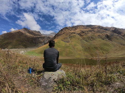
Reached Sankri around 5.30 pm and headed to Home stay. Temperatures at Sankri in October are still manageable unlike December and Jan where it will be extremely cold.
Sankri is a small village located in the Govind Wildlife Sanctuary in the Uttarkashi district. This village is base camp for 20+ treks.


Day 02 - Sankri to Chillargad( Actual trek starts today)
Trek distance- 12 Kilometres by Jeep & 11 Kilometres walk.
It was cozy night at Himalayan home stay (Provided by Trek organizers “The Crazy Mountaineers”) and I am up for the trek day!


Did warm up along with breathing exercise to start the day. Completed the backpacking with help of my guide and we were ready by 8 am for Sankri to Taluka jeep ride.


Due to road construction work, there have been multiple places vehicle cannot cross hence we had to change two vehicles, but ride on top of the jeep was highlight.
Reached Taluka around 9.30am which is about 2,110 meters altitude.


Filled our water bottles and hydration packs followed by some snacks and tea. Short briefing has been done on Do‘s and Don’ts along with plan for the day!
Today, the trek goes through Supin river which will be on right side. Plenty of water sources throughout the trail.


As we continue to walk, we cross Osla village where we spot Beautiful wooden house and then followed by Seema Village.


Crossed Seema and walked on the banks of Supin river till Chillar Ghad. It took 8 hours to complete 11 kilometres and camps are set right next to the river. Went through 10 mins of stretching session before snacks were served. It drizzled for a while but later no signs of rain. Dinner served at 8pm along with plan for tomorrow. Looks like it will be quite lengthy trek tomorrow. Filled water bottle and flask, most importantly emptied the bladder and we called it a day!


Day 03 - Chillar Ghad to Rainbasera
Trek distance- 12 kilometers
Altitude – 3,100 Meters / 10,200 ft.
Though body was tired, I had sleep in short spells till midnight, post which I hardly slept!


River sound could be the only reason! Temperatures are pretty normal as compared to the winter scene in Himalayan region. Early in the morning, seen a local who is rushing to hospital due to Bear attack. Heard from trek guide that, there are bears in this region.
Day started at 8am and breakfast and briefing was done. Plan laid out that we will push our self as much as we can since there won't be much steep climbs. Actual plan is to trek till Rainbasera, but we will push few more kilometers further. All in the group are experienced trekkers and they are aligned to the plan.


Walking along the Supin river, the trail will get steeper as we get close to the Debshu Bugyal. Upon reaching the Ruinsara Valley, the trail becomes a bit difficult with boulders on the route. As we keep walking you can look behind to catch the glimpse of the famous Osla Village. Clicked some amazing pictures there. Walking for another 30 minutes on an even trail, the Debshu Bugyal will begin. The Bugyal is huge pastureland. We had views of Kala Nag and the Black Peak from here. Spent some time there to regroup and started
From here, trail descends to cross the river. Now the river is on our right. Wooden bridges laid to cross the river and they do bounce when we walk over.


Within few kilometers there was a quick 15mins, lunch break and started our trek again. First time on this trek we have encountered rain and all had to put the rain gear. It hasn't lasted even for 30mins, Post lunch there are no steep climbs.


We have trekked close to four kilometers after crossing Rainbasera and it is 4.30pm. We have reached our Camp site by completing 14 kilometers trek and altitude is at 3300 meters. Soon we have realized temperatures are dropping and had to put extra layers of thermals.


Around 6pm, it was 8 degrees and it dropped further as it became dark. Finished stretching and hot pasta, Tea was served.
Dinner at 7.30pm followed by tomorrow‘s plan briefing. Looks like it will be a easy day.


Day 4 – Rainbasera (4 kilometres ahead) to Odari camp (Gaining additional day)
Trek distance - 8 Kilometres
Altitude – 4,000 Meters/13,100ft.
As per standard itinerary, trek must end at Ruinsara tal but we trek till next camp to gain additional day.
Camp site was set up nearby water stream and my tent got wet. Mat and sleeping bag was saving grace for the night. Sleep was intermittent but felt sufficient ahead of another big day.


Landscapes were wonderful throughout the trail. Reached Ruinsara lake after trekking about Hour and half. Spent some peaceful time over there and shot best time lapse when clouds were crossing over the lake and mountain.


Decent in the valley and Crossed Supin river and trekked towards dense forest.


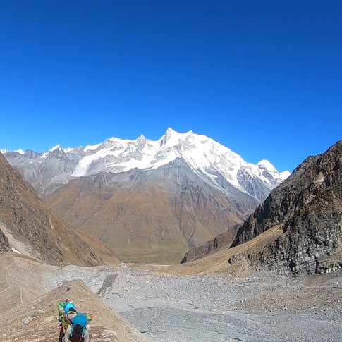
Post lunch, again trail ascents towards the Odari camp. As we climb, the views of Swargarohini will get better and clouds continue to pass over.


Reached Odari camp site at 3.30pm and this camp site is much better than yesterdays one. Camp site has complete views of Swargarohini and we have spent rest of the day clicking pictures.


This camp site is at 4,000 meters and this is first time I have trekked to such a high altitude.


Temperatures start dipping and cold breeze started hitting us as the day progressed. This resulted in mild headache. For a moment I thought, I have been hit by AMS but post dinner, I was back to normal. We did some rotation also for higher altitude to make sure we get used to higher altitude. Thumb rule - Climb high and sleep at lower altitude.
500 Meters altitude is the standard and safe altitude that can be gained per day at higher altitudes.
If will be challenging terrain from here on and we need to be extremely cautious.
Oxygen percentage in air is low at high altitude hence water intake has to be more to supply additional oxygen to body in the form of water.
There were plenty of water sources throughout the trail but make sure you fill the bottles at Ruinsara tal lake so that it will be sufficient till the base camp.
Camp fire was set up to beat the night temperatures. Soon dinner and tomorrows plan briefing was done.
Day 5 - Odari to Bali pass base: Most challenging and exhausting!
Trek distance & Duration - 5 Kilometers, 6 to 7 hours.
Trail – Steep & Technical ascent. Walk on mountain ridge.
By gaining extra kilometers every day, we are already ahead of a day, as per standard itinerary. I had mild headache in the night which was subsidized later. After breakfast, we have started ascending.


A kilometer from our camp, trail starts getting steep and it’s a ridge walk. Entire Ascent will be around 60 digress incline. Some places, the pass is very narrow.


Big challenge is the water source! Till Odari base, literally every 200 to 500 meters, there were water streams but from Odari, the scene is different. There is a water stream near camp site and after that its Bali pass Base camp.


Being extreme critical part of the day for trek, keeping our self hydrated and carrying adequate water is must.


Fill the hydration pack and water bottles from Odari base itself. I had to borrow water from fellow trekker; else I would have been in real trouble. However my water intake was less which eventually ended up in dehydration.

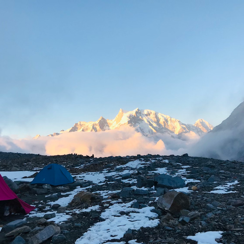


Around 3 pm, we have reached the base camp. I had a headache again. Trek lead had given me a tablet followed by SPO2 check. It was 74 which is supposed to be above 80 as we were already at 4660 meters altitude.


Also pulse was quite high. Had to drink around 2 bottles of water (650 ml each) followed by Wim Hoff breathing exercise. After an hour SPO2 came to 84 which is normal at this attitude!


Tomorrow being summit day and it is completely covered with snow, there was a session conducted on how to walk in snow and also, a rotation since we clock highest altitude of the trek!
During day closure briefing, we were told that summit push will start by 6 am and its going to be exciting, challenging long day!
Soon temperatures dropped to zero and even drinking also frozen.
Day 6 - Bali pass base camp to Lower Dhamni
Trek distance & Time: 14 kilometers & 10 hours
Trail: Steep & Technical
Altitude: Bali pass – 4950m/16207ft, Lower Dhamni 3,400m/11,100ft
Hardly slept about two hours as it will be difficult to sleep at high altitude also had a difficulty in breathing since my nose was blocked. To bring the situation back to normal (Drinking water, breathing exercise) it took around 3.30 am and had my alarm ringing by 5 am to get ready for summit climb.


The excitement of Summit had kept all my physical aside and i was ready by 6 am. Light breakfast followed by packed lunch and we headed to summit by 6.30 am. Walking on the snow wasn’t difficult for me as I had prior experience. Trail to summit was less accessed since very few attempt this trek.


Around 8 am reached summit and waited for fellow trekkers also to reach, soon finished rituals and also filming the best moments we waited for! Close to 500 meters of Summit climb is scary and adventurous.


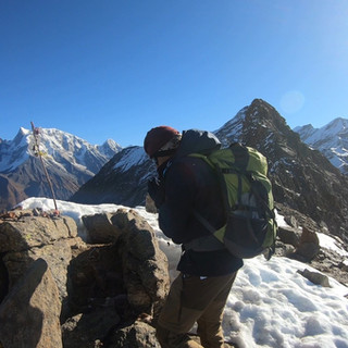


Celebrated the best moments at summit as this is the highest peak i have climbed. We forgot the pain & struggles we have been with 360 degrees views of the summit.


Views of Swargarohini, Bandarpoonch mountain range are spectacular. We need to be extremely cautious when walking or celebrating on summit as it’s very narrow.
Soon we have been given briefing on Descending! It looked dangerous and we didn’t ask for rope as all of the team members are experienced trekkers. I would say this is more difficult than the Summit climb. With extreme caution, we have started descending without anyone being hurt. From there it’s about 8 kilometers descend.


Views of Yamunotri valley with multiple waterfalls and clouds were really beautiful.
Here comes the most difficult part of the descent which is ridge walk. Almost none spoke about this difficulty in their experience (from what I have seen in YouTube). As we enter upper Dhamini, the trail goes through the mountain edges. Some of the places, you can barely keep half of the foot.


Entire stretch till lower Dhamini has got great views. Our camp was set up in lower Dhamni which is about two kilometers before the Yamunotri. Day was quite challenging but it’s worth!
We have appreciated staff for their support throughout the trek, as we may not get time tomorrow noon since most of us got different plans.


One of the important things, I have been doing this trek along with a wonderful experienced trekkers who meet once in a year in Himalayas. They have done some of the most difficult treks like Stock Kangri, Pin parvathi, Gochela and list goes on.. lot of learnings and takeaways for the past Six days!
Day 7 - Lower Dhamni to Janaki Chatti
Trek distance& Time: 8 Kilometers, 6 hours.
Trail: Descent
Probably one of the best camping sites during this trek where i slept for more than 6 hours!
Day started by 7 am. There will be 2 groups today, one will be going through Yamunotri shrine and other group will directly reach Janaki Chatti!


Obviously I preferred to go to Yamunotri. It took about 30 mins to reach Yamunotri trek route which is used in older days and it's still operational. After taking up that route, it took another one and half hours to reach Yamunotri dham.


Our trek lead spoke to the temple authority and they agreed to organize all the Pooja formalities for us ( at premium cost) Feeling proud moments were, we don't need to do online registration, if we come from Bali pass trek.


Took bath in the hot spring which is so refreshing and also, it's been 6 days! It was Friday and also Second day of Navaratri where priest told us that it's an auspicious day. Completed Pooja, took darshan and spent solid 2 hours.
Little top up to the stomach, we started descending from Yamunotri around 10.30 am.


It's 4.5 kilometers trek from Yamunotri Dham to Janaki Chatti. I have completed in one hour and fifteen mins. I was literally running on the trail just to check the strength of my knees which always troubles me when I do nothing. We have motivated lot of pilgrims throughout the way. Some of them enquired about our trek too. Around 12 pm, reached Janaki Chatti which is end point of the trek!
Boys have finished the final rituals with tons photographs and bid adieu to each other.


Took a cab from Janaki Chatti to Dehradun and reached around 8 pm.
Comments